
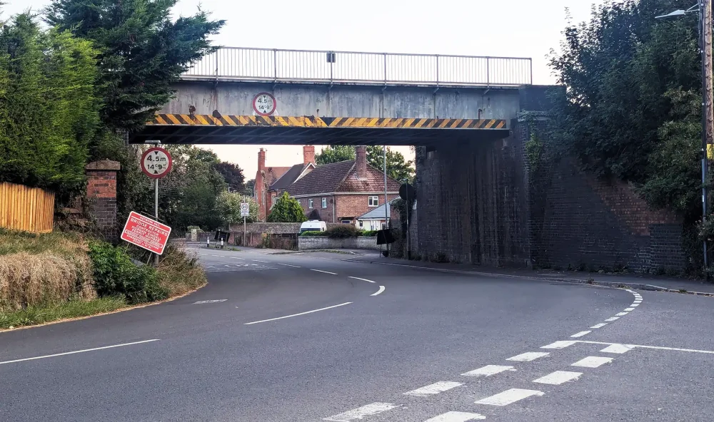
Network Rail has started work to repair the bridge over the A378 through the town, near the Tesco supermarket, closing the route until August 31.
Diversions are in place, but the closure is set to cause delays for thousands of drivers using the road each day – with the alternative route listed measuring some 35 miles – taking around an hour.
However, a Network Rail spokesperson said the repairs were urgent, as the bridge – built using a Western Box design – is already showing signs of cracking.
“There is a design defect at the end of each of these that may eventually result in fracturing of the steel beam. One has already started to crack,” the spokesperson went on.
READ MORE: A378 through Langport to close during rail bridge repairs
“We’ll strengthen the bridge by adding new support beams underneath. This will stop the weight of trains going through the older beams and causing fractures to form.
“The entire bridge will be grit-blasted, cleaned and repainted – and we’ll be fixing parts of the stonework at either end of the structure.”
The core work is set to last until August 31, with crews working “non-stop, day and night”, they added.
After that, weekend closures will be in place on September 13 and 14, and September 20 and 21.
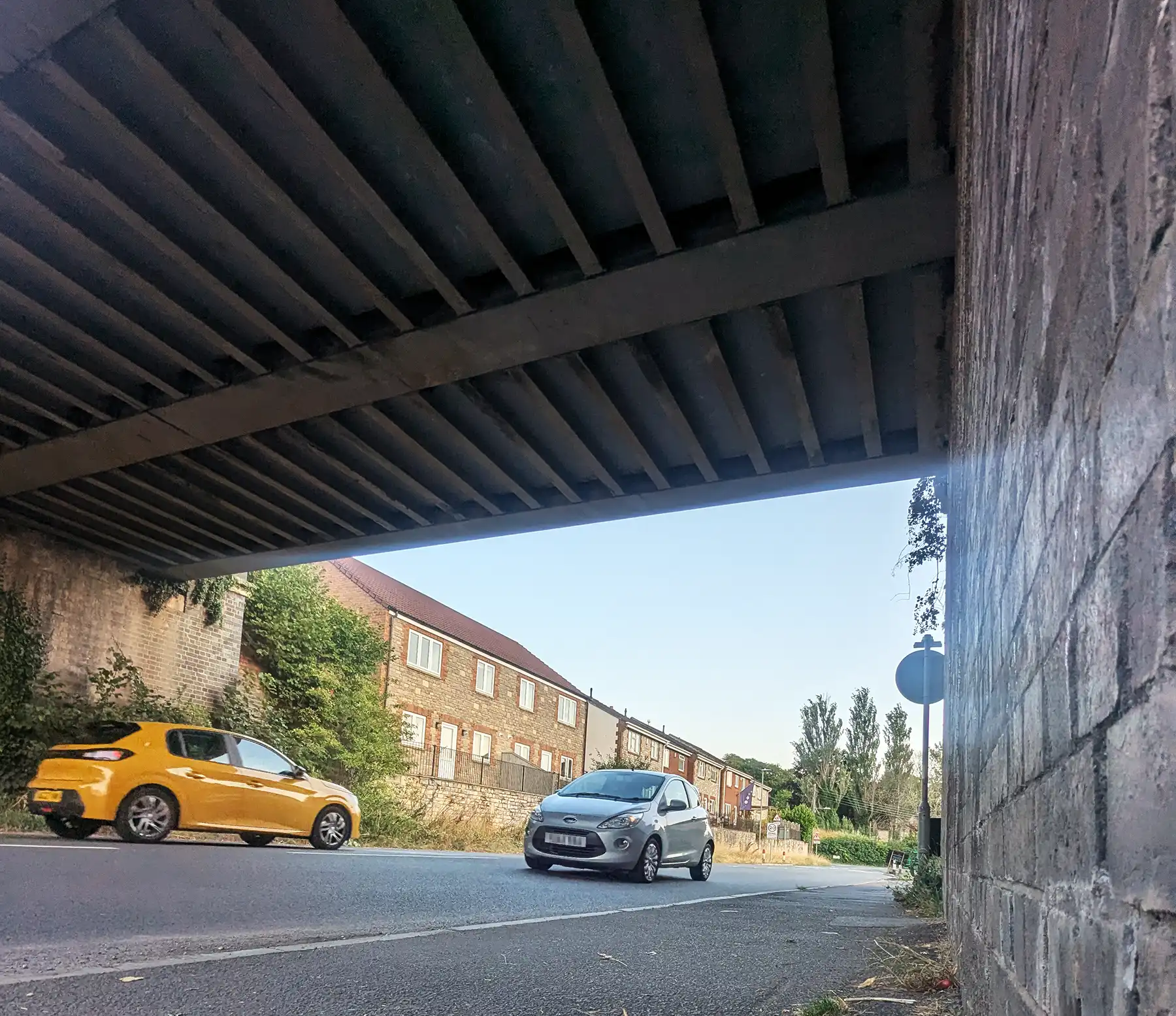
The road is the main route through Langport for thousands of drivers each day. Picture: Somerset Leveller
A compound has been set up behind the former Travis Perkins site, off North Street, with work being designed to keep disturbance to a minimum, the spokesperson said.
“We’ll be using super-silenced generators and directional lighting to keep disturbance to nearby residents to a minimum,” the spokesperson added.
“The nature of our work means some extra noise and traffic is unavoidable.
“We also need to work around the clock at times to complete the project as quickly and efficiently as possible.
“We’re sorry for any inconvenience and we’ll do our best to keep any disturbance to a minimum.”
READ MORE: South Somerset news from your Leveller
Diversion in place during Langport road closure
The diversion listed on the Travel Somerset website is detailed as being just over 35 miles long, and taking “about an hour”.
The full diversion – step-by-step as listed – is:
From Somerton Road:
137.20m: Turn sharp right towards Newtown Road
57.60m: Continue on Newtown Road
226.50m: Continue on Swallow Hill
353.20m: Continue on Swallow Hill
45m: Continue on White Hill
635.20m: Continue on
955.40m: Continue on
845.60m: Continue on High Street
196.10m: Turn sharp left towards Ridley Hill
300.40m: Continue on Beer Road
677.90m: Continue on Beer Road
869m: Turn sharp right towards
315.50m: Continue on
1.67km: Continue on
222.20m: Continue on New Road
34.20m: Turn sharp left towards Fore Street
330m: Continue on Fore Street
84.60m: Continue on High Street
454.30m: Continue on Main Road
202.90m: Continue on Grove Hill
118.80m: Continue on Grove Hill
599.10m: Continue on Burrow Wall
1.13km: Continue on Main Road
487.80m: Continue on New Road
139.60m: Continue on New Road
1.89km: Continue on New Road
520.20m: Continue on Main Road
2.85km: Continue on Main Road
642.50m: Continue on Glastonbury Road
1.01km: Continue on Glastonbury Road
1.88km: Turn slight left towards Bridgwater Road
921.90m: Continue on Bridgwater Road
495.70m: Turn sharp left towards Bridgwater Road
206.50m: Continue on Bridgwater Road
475.90m: Continue on Bridgwater Road
729.40m: Turn slight right towards
77.70m: Turn sharp right towards Walford Cross
52.60m: Turn slight left towards Bridgwater Road
1.60km: Turn slight right towards
59.20m: Turn left towards
68.90m: Turn slight left towards
15m: Continue on
60m: Turn sharp right towards
291.60m: Continue on Langaller Way
149.40m: Turn slight left towards Langaller Way
57.20m: Turn slight left towards Langaller Way
57.50m: Turn sharp right towards Langaller Way
37.40m: Continue on Langaller Way
17.20m: Turn slight left towards Langaller Way
43.90m: Turn sharp right towards Langaller Way
6m: Continue on Langaller Way
65.70m: Turn sharp left towards Langaller Way
73.30m: Turn slight left towards Langaller Way
57.20m: Turn slight left towards Langaller Way
254.30m: Turn slight left towards Langaller Way
58.60m: Turn slight left towards Langaller Way
74.50m: Turn sharp left towards Langaller Way
46.40m:Continue on Langaller Way
21.90m: Turn slight left towards Langaller Way
18.60m: Turn slight left towards Langaller Way
20.80m: Continue on Langaller Way
27.10m: Turn sharp right towards Langaller Way
46.50m: Turn slight left towards Langaller Way
58.60m: Turn slight left towards Langaller Way
252.70m: Continue on Langaller Way
323.10m: Turn left towards Langaller Way
39.70m: Turn slight left towards Langaller Way
43.30m: Turn sharp left towards Langaller Way
19m: Continue on Langaller Way
19.60m: Turn sharp right towards Langaller Way
44.30m: Turn slight left towards Langaller Way
13.80m: Continue on Langaller Way
32.60m: Turn sharp right towards Langaller Way
42.40m: Turn left towards Langaller Way
39.70m: Turn slight left towards Langaller Way
120.50m: Continue on Langaller Way
325.30m: Turn slight left towards Bridgwater Road
8.70m: Turn slight left towards Bridgwater Road
38m: Turn sharp left towards Bridgwater Road
14.40m: Continue on Bridgwater Road
22.50m: Turn sharp right towards Langaller Way
34m: Turn slight left towards Langaller Way
12.40m: Continue on Langaller Way
15.10m: Turn sharp right towards Langaller Way
24.80m: Turn slight left towards Bridgwater Road
8.70m: Turn slight left towards Bridgwater Road
828m: Turn slight left towards
74.30m: Turn slight left towards Toneway
452.40m: Turn slight left towards
57.30m: Turn slight left towards
420.60m: Turn slight left towards Ilminster Road
150.60m: Turn slight left towards Ilminster Road
645.90m: Turn sharp right towards Ilminster Road
22.20m: Continue on Ilminster Road
201.20m: Continue on Ilminster Road
262.40m: Turn slight left towards
190.70m: Turn sharp right towards
253.90m: Turn slight left towards
207m: Turn sharp right towards
382.70m: Continue on
48.70m: Turn slight left towards Toneway
18.40m: Continue on Toneway
32.80m: Continue on Toneway
470.90m: Turn sharp left towards Bridgwater Road
34.30m: Continue on Bridgwater Road
32.80m: Turn sharp right towards
74.30m: Turn slight left towards Toneway
452.40m: Turn slight left towards
57.30m: Turn slight left towards
420.60m: Turn slight left towards Ilminster Road
150.60m: Turn slight left towards Ilminster Road
800.20m: Continue on Ilminster Road
499.70m: Continue on Ilminster Road
2.31km: Continue on Langport Road
86.90m: Continue on Langport Road
11.80m: Turn slight right towards Mattock’s Tree Hill
304.30m: Continue on Mattock’s Tree Hill
942.50m: Continue on
353.60m: Continue on Ilminster Road
146m: Continue on Ilminster Road
188.30m: Turn sharp left towards Ilminster Road
1.87km: Continue on Langport Road
647.10m: Continue on Stonehead Hill
662.80m: Continue on Stonehead Hill
1.70km: Continue on
1.07km: Continue on
2.18km: Continue on
2.28km: Continue on
1.99km: Continue on
2.67km: Continue on
1.86km: Continue on Cheapside
69.20m: Turn slight left towards North Street
336.80m: Continue on North Street
North Street
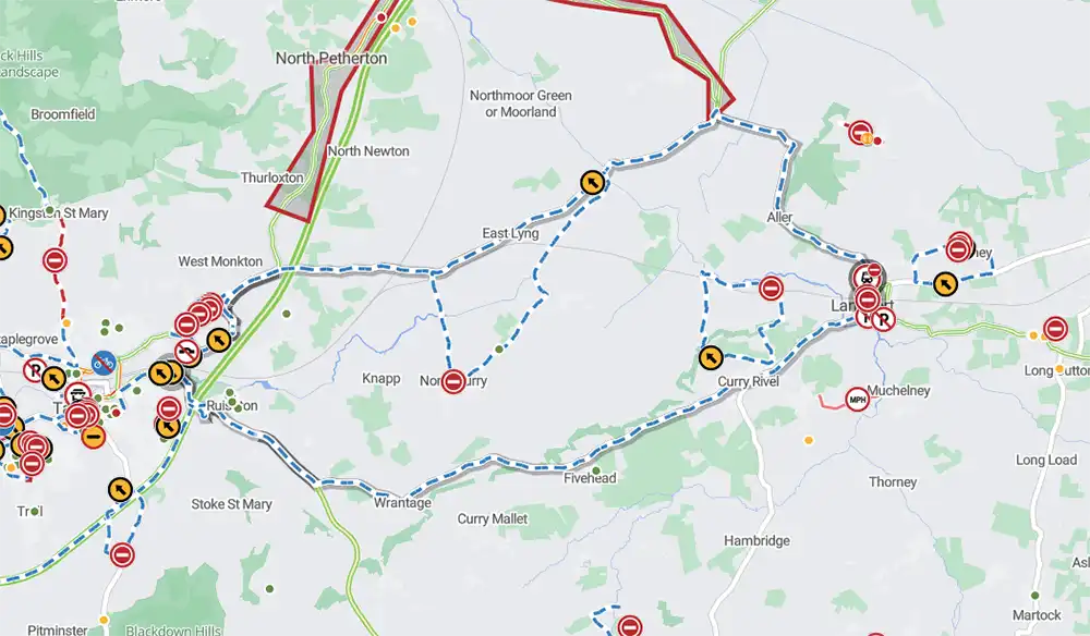
The diversion route around Langport during the railway bridge work


Leave a Reply