
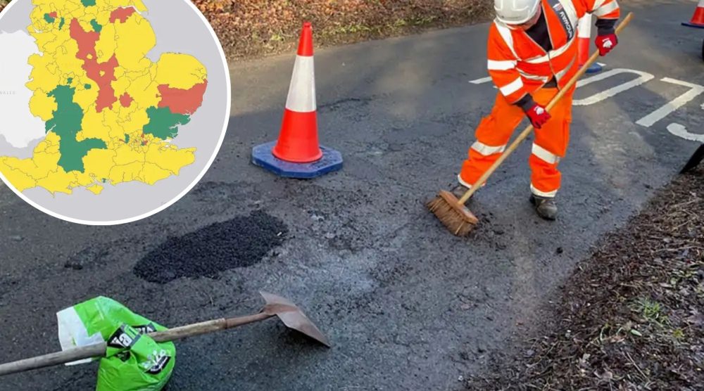
SOMERSET is ranked as ‘amber’ on a new map rating how well it is doing on filling potholes.
The Department for Transport (DfT) has released a new map ranking local highway authorities (LHA) across the country – red, amber, and green – for their performance in tackling the issue.
It comes as the Government said it wants to give drivers the chance to see how their authority is performing, having handed them £7.3 billion to tackle the pothole problem.
Transport Secretary, Heidi Alexander, said: “For too long, drivers have paid the price because our roads were left to deteriorate. I have heard time and again their frustration on footing the bill because they hit a pothole – money they should never have to spend in the first place.
“We’ve put our money where our mouth is, increasing the funding for local highway authorities with £7.3 billion to fix roads and given them the long-term certainty they have been asking for.
“Now it’s over to them to spend the money wisely, and for the first time, we are making sure the public can see how well councils are doing in delivering the improvements they want to see in their local area.”
The red, amber, green ratings are based on three areas:
- the condition of local roads
- how much LHAs are spending on road repairs
- whether they are following best practice in maintaining highways
Areas that scored a green rating – including Leeds, Sandwell and Manchester – were able to demonstrate they are investing in more long-term preventative measures rather than just patching up potholes, while also maintaining good road conditions and investing significantly in improving roads.
‘Amber’-ranked LHAs showed some of these qualities with room for improvement in individual areas, while those rated ‘red’ are not yet meeting the expected standards in one or several areas measured by the ratings.
Somerset was ranked as an ‘amber’ authority, along with North Somerset, Dorset, Devon and Bath & North East Somerset. Wiltshire was ranked ‘green’.
READ MORE: More than 15,500 potholes filled in Somerset so far in 2025
READ MORE: Somerset B and C roads among the worst in the country, according to analysis
Edmund King, AA president and founding member of the Pothole Partnership, said: “The top transport demand for 96% of AA members is fixing potholes with increased investment in repairing and upgrading roads.
“We welcome this government initiative to hold local highways authorities to account, which should help to promote the Pothole Partnership objective of more proactive and permanent repairs.”
And Caroline Julian, brand and engagement director of British Cycling and founding member of the Pothole Partnership, added: “For cyclists, potholes are far more than an annoyance. One unexpected impact can cause a serious crash, life-changing injury or, in the worst cases, a fatality.
“Safe riding depends on safe roads, and a smooth, well-maintained surface isn’t a luxury for cyclists, it’s essential for their safety.
“This new mapping tool is a step forward. It gives riders clear insight into how well their council is maintaining the routes they rely on every day, while holding decision-makers to account.”
Motoring group, the RAC, recently published details of an increase in claims over potholes in the UK, with more 53,000 in 2024.
RAC head of policy, Simon Williams, said: “These new ratings are a positive move that will help drivers understand how councils are performing when it comes to improving the state of local roads.
“While there are examples of good road maintenance practice taking place, this isn’t consistent across the country and means drivers have, for too long, been left with substandard roads.
“We hope this initiative, plus the promise of longer-term funding for councils to allow them to plan and carry out much-needed preventative maintenance, means we’re finally on the way to having smoother, better roads.”
READ MORE: Motoring news from your Somerset Leveller

The map showing each area’s rating. Picture: Department for Transport


The worse place Somerset at potholes
U can see in front of Aldi