
JANUARY 2014 will stick in the memory of many Somerset residents, sending a shiver down the spine.
For that month saw an estimated 10% of the Levels underwater as the most widespread flooding in living memory struck the county.
Sleepy Somerset was suddenly catapulted to the front pages of national newspapers and the lead item on TV news.
More than 600 homes and 16 farms were evacuated, with many forced out of their homes for months.
The floods caused damage estimated at £10 million, with some 14,000 hectares of grazing land said to be underwater for three to four weeks, and tourism taking a hit of around £200m, according to estimates.
Roads were hit, including the A361 between Taunton and Street, while train services connecting Taunton and Bridgwater to Bristol were also closed.

A satellite image showing flooding across the Somerset Levels in 2014. Picture: NASA
In response, Prime Minister David Cameron said “money is no object in this relief effort”.
Ah, but what about after the immediate need for relief had passed?
“It will take time, but together we will deal with these floods, we’ll get our country back on its feet and we will build a more resilient country for the future,” Mr Cameron said at the time.
However, as time progressed, it seemed money was actually an object afterall.
In the aftermath of the 2014 floods a new body was set up – the Somerset Rivers Authority (SRA) – to reduce the “risks and impacts of flooding across Somerset”.
However, despite Mr Cameron’s earnest claims, it eventually fell to the people of Somerset to pay for their “more resilient country”, with an additional sum added to the council tax bill of every home in the area.
That money hands the SRA £3m a year, with the Axe Brue and Parrett Internal Drainage Boards (IDBs) also giving a combined £20,000 annually.
So, we give the SRA just over £3m a year to reduce the possibility and the impact of flooding.
But, as towns and villages across Somerset once again embark on a clean-up operation following heavy rain, they are asking what they have to show for that money.
The SRA has done things. Since 2014, it points to initiatives including:
- launching phase one of a River Sowy – King’s Sedgemoor Drain (KSD) enhancements scheme
- dredging activities on the River Parrett
- aiding development work on the Bridgwater Tidal Barrier
- overseeing natural flood management works to slow the flow of water as part of the Hills to Levels project
- implementing the Taunton Strategic Flood Alleviation Improvements Scheme
- launching a new Highbridge surface water pumping station
The Bridgwater Tidal Barrier is a massive scheme that could bring tangible benefits across the county, reducing flood risk for more than 11,000 homes and 1,500 businesses.
But it won’t be operational until 2027.

The Bridgwater tidal barrier will not be operational until 2027
An SRA spokesperson said the barrier was just one of a raft of initiatives it was involved with: “(The SRA) has funded a large number of measures to reduce the risks and impacts of flooding across Somerset, and many improvements can be seen throughout the county.
“Every year the SRA gives grants totalling around £3m for works that reduce the risks and impacts of flooding.
“Schemes and activities are largely carried out by members of the SRA partnership, such as Somerset Council, the Internal Drainage Boards, and the Environment Agency, as they have the powers and operational resources to deliver works on behalf of the SRA.
“Associated bodies such as Exmoor National Park Authority, the National Trust and Somerset Wildlife Trust may also get grants, while the SRA’s new Community Flood Action Fund has created opportunities for many smaller organisations such as town and parish councils to take simple, effective local action.”
The Environment Agency (EA), which has worked with Somerset Council in developing the barrier plans, said it was still carrying out work as the scheme progresses.
A spokesperson said: “The EA works tirelessly to better protect Somerset communities from the risks and impacts of flooding. We operate several hundred assets 24/7, spending £8-9m each year on their inspection, operation and maintenance, while also carrying out 120km of machine channel clearance annually and responding to incidents all year round.
“Alongside our other important work as part of the Somerset Rivers Authority partnership, this helps reduce flood risk for thousands of homes and businesses across the region.”
To ensure the tidal barrier project is delivered, earlier this month the Government announced it was giving the scheme £43m in the latest round of Plan for Change funding.
Secretary of State for Environment, Food and Rural Affairs, Steve Reed, said: “The storms this winter have devastated lives and livelihoods.
“The role of any Government is to protect its citizens. Under our Plan for Change, we are investing a record £2.65 billion to build and maintenance flood defences to protect lives, homes and businesses from the dangers of flooding.”
So the scheme is coming.
And it should be said, many of the complaints from residents following 2014 have been acted on; There has been dredging, there are more pumps, drainage has been improved and, despite record amounts of rainfall, we haven’t seen the apocalyptic scenes of a decade ago.
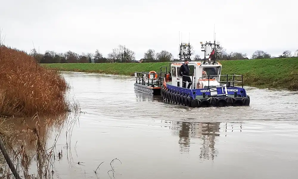
Dredging has taken place on the River Parrett and beyond. Picture: SRA
None of this, of course, is of much comfort to people in Chard, in Ilton, or anywhere seriously hit by flooding in recent months.
But to be fair to the SRA and partners, there is no way for us to accurately predict what might have happened had these things not been done.
Somerset is always going to be prone to flooding. The Levels are a low-lying area of some 160,000 acres, with efforts to control water levels taking place for thousands of years – and we are constantly changing the landscape.
For example, the recent upgrade of the A303 between Sparkford and Ilchester prompted concerns over the impact on surrounding areas during heavy rainfall.
Siân Hopkins, senior project manager for the scheme, said: “We are aware of increased flooding across the Somerset and surrounding area and, while confident our scheme has not increased the risk of flooding in the area, we have worked with the Environment Agency and Somerset Council to identify opportunities to improve the situation.
“Drainage has been designed so that surface water can run off the extra area of the road surface we’ve put down, along with other mitigation.
“This includes five attenuation ponds, drainage ditches, pipes and gullies to drain surface water quickly and safely, protecting the surrounding land from flooding.
“We will continue to monitor the situation and look for further collaborative opportunities to reduce the risk of flooding where possible.”
READ MORE: OPINION: Climate change, hysteria, denial – and a 70-year-old warning…
READ MORE: Have your say on Somerset flooding at drop-in events
Obviously, theories abound in conversation about the causes of flooding in various parts of the county, something a Somerset Council spokesperson addressed.
“The causes of flooding are complicated and vary from place to place,” they said. “There are all sorts of contributing factors, not least land use and the finite capacity of the highway surface drainage systems that cannot deal with the intensity of rainfall.
“Underlying all of this are the increasingly severe weather events we are experiencing and are likely to see more of in the future.
“There will be an investigation to fully understand the circumstances of the latest flooding incident.
“The highways drainage system and gullies are there to get water off the highways as soon as possible and keep transport links open.
“The flooding we have seen recently is not a problem that can be solved by gulley clearance.
“We know from previous events that run-off from land is a major factor and this tends to overwhelm all drainage systems, including highways systems.
“The fact that the maintenance regime of gullies was significantly increased following flooding in Chard in 2021 for example, or that the SRA has made funding available to increase maintenance frequency across the county, yet flooding was still a problem in some of these areas on Sunday, underlines the fact that highways drainage issues is simply not the root cause of the problem.
“Coping with flood incidents needs a partnership approach in terms of identifying potential ways to reduce the harms, and that is what we are engaged in.
“It is also about adapting as communities and building resilience.”

Pumping stations, like this one at Westover, can sstruggle to cope in severe rains. Picture: SRA
Somerset Council has also announced a series of drop-in events where residents can speak to the experts and organisations, as well as giving their thoughts on flooding – and what can be done.
EA chair Alan Lovell said climate change would lead to more flooding in the future – with money from the Plan for Change pot helping alleviate it as much as possible – something we considered in a recent opinion piece.
“The impact of flooding on our communities will only become greater as climate change brings more extreme weather like Storms Bert, Conall and Éowyn,” he said.
“With this new funding (for the tidal barrier), we will work closely with the Government to deliver the vital projects that are needed across the country, ensuring our investment goes to those communities who need it the most.”
Somerset needs even more investment to tackle current flooding flashponts – and to adapt for more that are coming. We can only hope the efforts our money pay for will not take too long to have an impact.
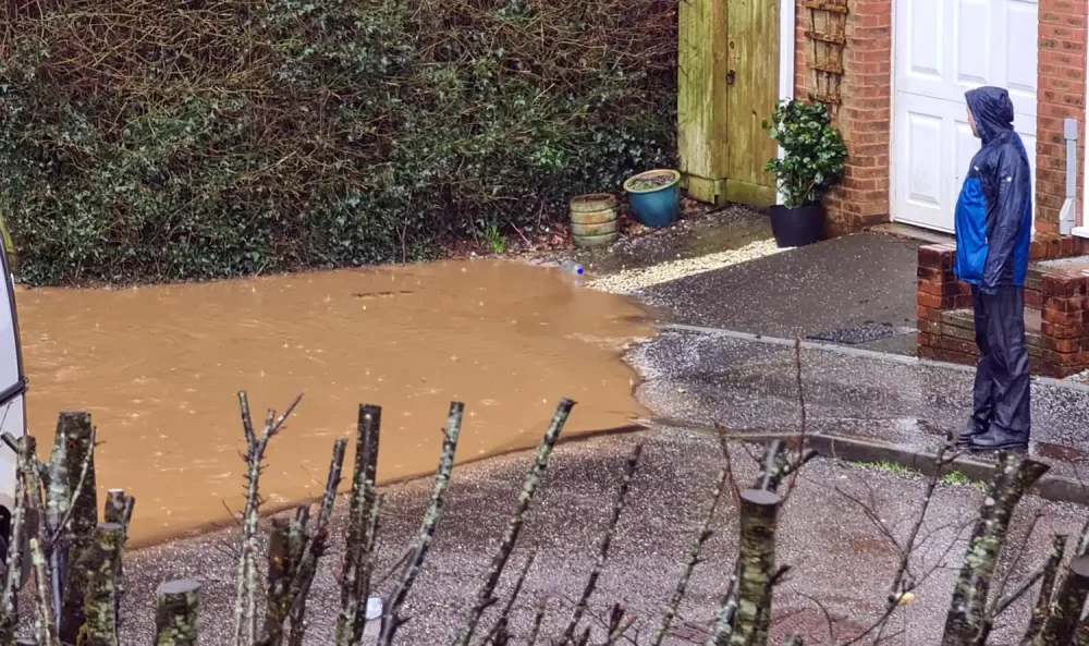
Flooding at Ilton last month. Picture: Jo Jeffrey-Palk


Leave a Reply